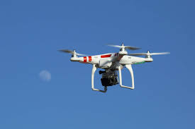
UAV Drone
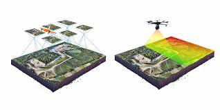
Photogrammetry
High-resolution 3D terrain mapping and slope geometry analysis using unmanned aerial vehicles.
Drone Photogrammetry in Mining
Unmanned Aerial Vehicle (UAV) photogrammetry fills the critical gap between satellite monitoring and ground sensors — providing centimeter-resolution 3D models of mine slopes that can be rapidly updated without extensive field survey effort.
A drone equipped with a high-resolution camera systematically photographs the mine slope from multiple overlapping angles. Photogrammetry software then reconstructs a precise 3D model from these images using computer vision algorithms (Structure from Motion).
By comparing 3D models from different dates, geotechnical engineers can detect slope movement, measure crack widths, and quantify volume changes with remarkable precision — all without placing personnel in hazardous areas.
UAV Survey Workflow
Define flight area, altitude, overlap percentage (80–90%), and camera trigger points using mission planning software (e.g., DroneDeploy, Pix4D Capture).
Drone executes autonomous flight, capturing hundreds of overlapping high-resolution images with GPS position tagged to each photo.
Photogrammetry software detects common feature points across overlapping images and aligns them to reconstruct camera positions in 3D space.
Dense image matching generates a point cloud with millions of 3D points representing the mine slope surface in full photorealistic color.
The point cloud is interpolated into a smooth Digital Elevation Model (DEM) — a georeferenced raster of ground elevations used for slope analysis.
Comparing DEMs from different survey dates quantifies slope movement, identifies crack development, and measures volumetric changes in dumped material.
What the UAV Survey Produces
Dense Point Cloud
Millions of colorized 3D points representing the entire slope surface with centimeter spacing. Used for detailed visual inspection and crack identification.
Digital Elevation Model
Georeferenced grid of elevation values enabling slope angle calculation, cut/fill volume measurement, and bench geometry analysis.
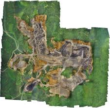
Orthophoto Map
Geometrically corrected aerial photograph with accurate scale and coordinates. Used for crack mapping and surface condition assessment.
UAV Applications in Open Cast Mining
Dump Slope Monitoring
Regular UAV surveys of waste rock dumps detect progressive settlement, toe bulging, and surface cracking that indicate developing instability.
Pit Wall Stability
3D models of open pit high walls reveal bench face conditions, catch berm integrity, and overall pit slope geometry vs design specifications.
Post-Blast Inspection
Immediate post-blast drone surveys assess the effect of blasting on slope stability without exposing personnel to re-entry hazards.
Stockpile Volume
Accurate volumetric measurement of ore and waste stockpiles for inventory management, replacing time-consuming manual survey methods.