Satellite InSAR
Monitoring
Synthetic Aperture Radar interferometry for millimeter-precision ground deformation mapping at mine scale.
What is InSAR?
Interferometric Synthetic Aperture Radar (InSAR) is a remote sensing technique that uses radar signals transmitted from satellites to detect and measure surface deformation with extraordinary precision — capable of measuring ground movements as small as a few millimeters across areas of hundreds of square kilometers.
Unlike optical satellites which measure reflected light, SAR satellites transmit their own microwave pulses and measure the reflected signal. This makes them independent of sunlight and capable of penetrating cloud cover — critical advantages for monitoring mines in tropical or high-altitude environments.
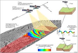
When two or more SAR images of the same area are acquired at different times, subtle changes in the ground surface cause measurable phase differences in the radar signal. InSAR processing extracts these differences to create deformation maps (interferograms) showing exactly where and how much the ground has moved.
InSAR Processing Workflow
Two or more SAR images of the mine area are acquired at different dates (typically 6–12 day intervals). Sentinel-1 (ESA, free) or commercial satellites like COSMO-SkyMed are commonly used.
The two SAR images are precisely aligned (co-registered) to sub-pixel accuracy so that corresponding ground pixels are exactly matched before phase comparison.
The two images are multiplied (one conjugate) to form an interferogram — a colorful fringe pattern where each complete color cycle represents approximately 2.8 cm of ground movement (for Sentinel-1 C-band).
Goldstein or other filters reduce noise (decorrelation) in the interferogram caused by temporal changes in vegetation or bare ground surface conditions.
Since the interferogram phase is cyclical (0–2π), phase unwrapping converts the ambiguous wrapped phase into an absolute deformation value by integrating phase gradients across the image.
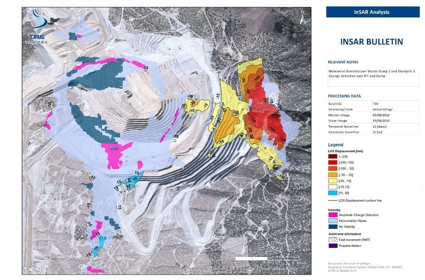
The final output is a georeferenced deformation map showing ground displacement (in mm) for every pixel in the image. Areas of active slope movement appear as concentrated fringe patterns.
InSAR in Mining
InSAR has become an increasingly valuable tool for large-scale mine monitoring because it provides historical and ongoing ground deformation data without requiring access to potentially hazardous slope areas.
Open Pit Slope Stability
Detecting slow creep movements on pit walls that may precede major failure events, allowing geotechnical engineers to intervene early.
Waste Dump Settlement
Monitoring settlement and creep in waste rock dumps and tailings facilities to ensure they remain within design stability limits.
Mine Subsidence Mapping
Tracking ground subsidence above underground workings to protect surface infrastructure and assess mine closure risks.
Landslide Hazard Assessment
Identifying areas of active landslide movement in the broader mine catchment that may affect roads, facilities, or water courses.
Why InSAR for Mine Monitoring
Millimeter Precision
Sentinel-1 C-band radar can detect surface displacements as small as 3–5 mm between acquisition dates, far exceeding conventional survey accuracy at this scale.
No Site Access Required
Satellite InSAR monitors slopes from orbit — no personnel need to access hazardous high walls or unstable dump areas for measurement.
Historical Analysis
Free Sentinel-1 data archives go back to 2014, enabling retrospective analysis of slope movements before monitoring programs were established.
All-Weather Capability
SAR radar signals penetrate cloud cover, smoke, and dust — critical for monitoring mines in tropical regions with frequent cloud cover.
Explore Satellite Data
Sentinel-1 radar satellite data used for InSAR deformation monitoring can be explored directly through the Copernicus Data Space Browser. This platform provides access to global SAR imagery used for ground deformation studies in mining, landslide monitoring, and infrastructure stability analysis.