National Level Technical Symposium 2026

Hybrid Multi-Scale
Slope Monitoring
for Open Cast Mines

Integrating Satellite Surveillance, UAV Inspection, and IoT Real-Time Monitoring for Comprehensive Mine Slope Safety

Geotechnical Engineering
IoT Systems
Remote Sensing
Cloud Analytics
PROJECT TEAM
Syed Hamed Mohiuddin ; P. Karthik ; Swarthik and team
Guide: Dr. M. Satish Kumar Sir

Why Slope Monitoring Matters

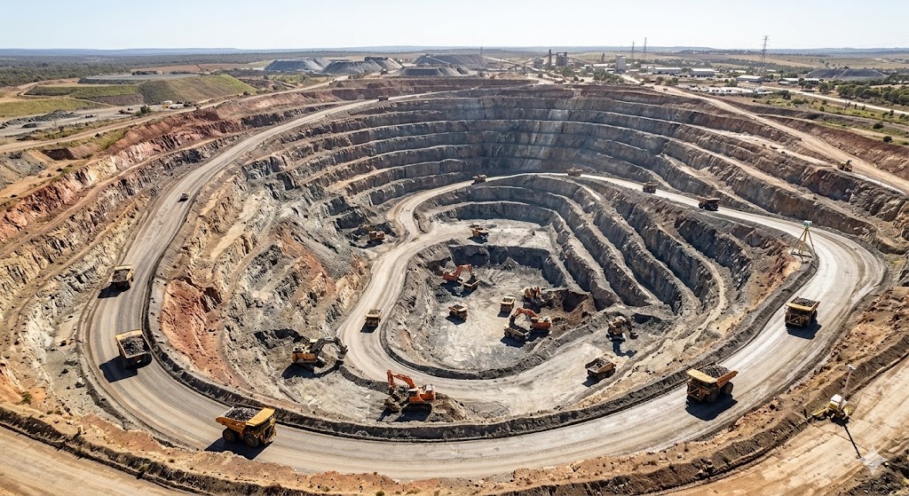
Slope failures are among the most dangerous and costly hazards in open-cast mining operations worldwide. A single slope collapse can result in loss of life, equipment damage, and significant production interruptions.

Modern open-cast mines excavate rock and soil to extraordinary depths, creating steep slopes and waste dumps that must be continuously monitored. Traditional periodic surveying methods are no longer sufficient โ€” mines require continuous, automated, multi-scale monitoring that can detect subtle movement long before catastrophic failure.

This research project proposes and demonstrates a Hybrid Multi-Scale Slope Monitoring Framework that combines three complementary technologies operating at different spatial and temporal scales to provide complete mine slope coverage.

Explore the Framework โ†’
Open Cast Mine Slope Monitoring

The Monitoring Hierarchy

Three integrated monitoring layers provide complete spatial coverage โ€” from continental-scale satellite imagery down to ground-level IoT sensors embedded directly in the slope.

๐Ÿ›ฐ
Satellite Monitoring
InSAR ยท Macro Scale ยท Wide Area
โ†“
๐Ÿš
UAV Monitoring
Drone Photogrammetry ยท Meso Scale
โ†“
๐Ÿ“ก
IoT Sensor Monitoring
Real-Time ยท Micro Scale ยท In-situ
โ†“
๐Ÿ–ฅ
Mine Control Center
Integrated Decision Support
๐Ÿ›ฐ

Satellite โ€” Macro Scale

Covers the entire mine footprint using radar interferometry (InSAR). Detects millimeter-level ground deformation over weeks and months. Ideal for regional landslide and subsidence mapping.

๐Ÿš

UAV โ€” Meso Scale

Drone photogrammetry produces centimeter-resolution 3D terrain models. Used for slope geometry analysis, crack detection, and post-blast inspections of pit walls and waste dumps.

๐Ÿ“ก

IoT Sensors โ€” Micro Scale

Embedded sensor nodes continuously monitor tilt, soil moisture, and vibration at critical slope locations. Data streams to the cloud every few seconds for real-time risk assessment.

What This Project Delivers

โšก

Real-Time IoT Monitoring

ESP32-based sensor nodes measure slope tilt, soil moisture, and vibration continuously, transmitting data wirelessly to cloud platforms with automated risk scoring.

๐Ÿ›ฐ

Satellite InSAR Analysis

Synthetic Aperture Radar interferometry detects ground surface deformation at millimeter precision over wide mine areas without on-site access requirements.

โœˆ

UAV Photogrammetry

Drone-based aerial surveys generate high-resolution 3D point clouds and Digital Elevation Models of pit walls, enabling rapid change detection and volume measurement.

โ˜

Cloud Analytics Platform

ThingSpeak cloud platform with MATLAB analytics automates data visualization, trend analysis, and Slope Stability Index (SSI) calculation for decision support.

๐Ÿงช

Physical Prototype Model

A scaled open-cast mine bench model demonstrates the complete monitoring system under controlled laboratory conditions with simulated slope instability events.

๐Ÿ“

SSI Risk Algorithm

A custom Slope Stability Index formula combines sensor readings into a unified risk score with three classification levels: SAFE, WARNING, and DANGER.

Sensor Data Preview

Simulated real-time sensor readings โ€” refreshes every 2.8 seconds

Mine Slope Monitor โ€” Node 01
Live Feed
Tilt Angle
--ยฐ
Soil Moisture
--%
Vibration
NONE
SSI Score
--
Risk Status
โœ“ SAFE
View Full Dashboard โ†’

Project Sections