Future Scope
& Research Directions
The next generation of mine slope monitoring — AI prediction, digital twins, autonomous safety systems, and global deployment.
Where This Research Is Heading
The Hybrid Multi-Scale Slope Monitoring Framework demonstrated in this project represents the first generation of an integrated mine safety system. While the current prototype validates the core concept, there is a rich roadmap of technical enhancements and research directions that will significantly expand the system's capabilities.
The convergence of Artificial Intelligence, Digital Twin technology, edge computing, and 5G connectivity will enable the next generation of mine slope monitoring systems to move from reactive alerting to predictive failure prevention — saving lives, protecting assets, and transforming mine safety management globally.
The following research directions have been identified as the highest-priority extensions of the current project.
Eight Future Enhancements
AI-Based Slope Failure Prediction
Machine learning models (LSTM recurrent neural networks, Random Forest, XGBoost) trained on historical sensor time-series data to predict slope failure events hours or days before they occur. The AI system would learn the characteristic sensor pattern signatures that precede slope collapse — enabling truly predictive rather than reactive safety management. Training data would include records from both real mines and controlled laboratory experiments.
Full Satellite–UAV–IoT Data Fusion
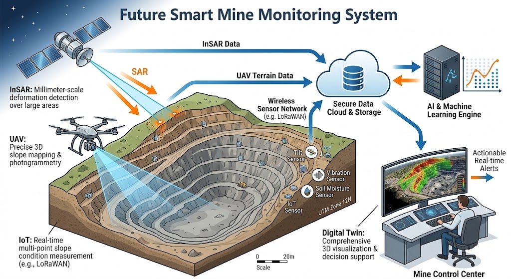
Development of a unified data fusion algorithm that automatically integrates InSAR deformation maps, UAV 3D terrain change models, and IoT real-time sensor readings into a single spatially referenced mine hazard map. This would allow the control center to see — on a single dashboard — how regional slope movements (from satellite) correlate with local sensor readings, enabling much more accurate risk assessment than any single technology can provide alone.
Digital Twin Mine Monitoring System
Creation of a real-time 3D digital twin of the mine — a continuously updated virtual replica that mirrors actual mine conditions. The digital twin would ingest sensor data, satellite deformation measurements, and UAV survey results to maintain an always-current 3D model of slope conditions. Engineers could simulate "what-if" scenarios (e.g., heavy rainfall, additional excavation) to predict future stability and optimize safe operating limits without physical testing.
Automated Mine Safety Warning System
Integration with mine-wide communication infrastructure to deliver automated, graduated alerts directly to personnel mobile devices, mine control centers, and equipment operators when risk thresholds are exceeded. The system would trigger evacuation protocols, equipment shutdowns, and emergency response team notifications automatically — without requiring human intervention — potentially saving critical minutes during fast-onset failure events.
Edge AI Processing on ESP32-S3 / Raspberry Pi
Deploying lightweight AI inference models directly on edge devices (upgraded microcontrollers or single-board computers) so that risk prediction can occur locally even when cloud connectivity is disrupted. This addresses one of the key vulnerabilities of cloud-dependent monitoring systems operating in remote mine environments with unreliable internet connections.
Dense Wireless Sensor Networks
Expanding from single-node to multi-node sensor networks using LoRaWAN or Zigbee mesh protocols to monitor entire pit walls and dump slopes with spatial resolution. A network of 20–100 sensor nodes would create a real-time slope deformation field map, capturing not just point measurements but spatial patterns of movement that are far more informative for stability assessment.
Integration with Autonomous Mining Equipment
Connecting the slope monitoring system to autonomous haul trucks, drills, and excavators so that equipment operating near hazardous slopes automatically receives real-time stability data. Equipment could be programmed to autonomously adjust operating patterns, increase standoff distances, or suspend operations when slope risk levels rise — creating a fully automated safety response without relying on human-in-the-loop decision making.
Regulatory Compliance & International Standards
Development of standardized monitoring protocols, data formats, and reporting frameworks aligned with international mine safety standards (ISO, ICMM, national mining regulations) to facilitate adoption of the hybrid monitoring framework by commercial mine operators. This includes validation studies at operating mines, third-party verification of sensor accuracy, and development of guidance documents for geotechnical engineers implementing the system.
Research Timeline
Collaborate on This Research
This research project welcomes collaboration from mining companies, geotechnical engineering firms, satellite data providers, and academic institutions interested in advancing mine slope safety technology.