Hybrid Multi-Scale
Monitoring Framework
Combining three complementary technologies across macro, meso, and micro scales for complete mine slope surveillance.
Why Multi-Scale Monitoring?
No single monitoring technology can efficiently cover all spatial and temporal scales relevant to mine slope safety. Each method has distinct strengths and limitations — the key insight of this research is that their weaknesses are complementary.
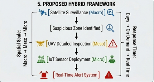
By combining Satellite InSAR (wide area, long-term), UAV Photogrammetry (medium area, periodic high-detail), and IoT Sensors (local area, continuous real-time), a mine operator gains complete observability of slope conditions at every relevant scale.
Data from all three layers converges at the Mine Control Center where it is fused, analyzed, and used to generate actionable safety decisions.
Satellite InSAR Monitoring
Large-area ground deformation detection using Synthetic Aperture Radar interferometry.
✅ Capabilities
- Covers hundreds of square kilometers per satellite pass
- Detects ground deformation at millimeter-level precision
- Monitors long-term slope movement trends over months and years
- No physical access to hazardous slopes required
- Historical archive allows retrospective analysis
- Operates through cloud cover (radar is weather-independent)
⚠ Limitations
- Not real-time — requires satellite revisit intervals (6–12 days)
- Requires specialist processing software (e.g., SNAP, GAMMA)
- Results can be affected by vegetation and atmospheric effects
- Cannot detect rapid sudden-onset failures
- High cost for commercial satellite tasking
UAV Drone Monitoring
High-resolution 3D terrain mapping and slope geometry analysis using drone photogrammetry.
✅ Capabilities
- Centimeter-level 3D terrain models (point clouds and DEMs)
- High-resolution slope geometry and face angle measurement
- Crack and surface deformation detection
- Post-blast slope inspection without personnel entering the blast zone
- Stockpile volume measurement with high accuracy
- Rapid deployment — survey completed in hours not weeks
⚠ Limitations
- Not continuously operational — periodic survey flights only
- Requires favorable weather and regulatory airspace approval
- Battery endurance limits flight area per mission
- Significant data processing time for large datasets
IoT Real-Time Monitoring
Embedded sensor nodes provide continuous, second-by-second slope condition monitoring with automated risk classification.
✅ Capabilities
- Truly real-time monitoring — data every few seconds
- Immediate slope movement and tilt angle detection
- Continuous soil moisture tracking (rainfall infiltration)
- Vibration event detection from blasting or ground movement
- Automated Slope Stability Index calculation
- Low-cost scalable sensor network deployment
⚠ Limitations
- Only monitors point locations — limited spatial coverage
- Sensors require periodic maintenance and calibration
- Wireless communication may be unreliable in deep pits
- Physical sensor installation on unstable slopes carries risk
Technology Comparison
| Attribute | 🛰 Satellite InSAR | 🚁 UAV Photogrammetry | 📡 IoT Sensors |
|---|---|---|---|
| Spatial Scale | Macro (km²) | Meso (100s m²) | Micro (point) |
| Update Frequency | Days to weeks | Hours (flight schedule) | Seconds (real-time) |
| Deformation Precision | Millimeters | Centimeters | Degrees / % / Event |
| Setup Cost | High | Medium | Low |
| Requires Site Access | No | Yes (airspace) | Yes (installation) |
| Weather Dependent | No (radar) | Yes | No |
| Automation Level | Semi-automated | Partially automated | Fully automated |
| Real-Time Alerting | No | No | Yes |
Converging at the Control Center
All three monitoring streams feed into a central Mine Control Center where data is fused, analyzed, and used to support real-time safety decisions.
InSAR Data
Ground deformation maps, subsidence rates, long-term movement vectors
Mine Control Center
Integrated data fusion, risk assessment, safety decisions
IoT Data
Real-time tilt, moisture, vibration, SSI risk scores